Uncovering Your Every Move: How Cell Phone Tracking Really Works
Download MP3So how exactly does cell phone tracking or GPS tracking with cell phone data work? Well, first look at this photo of a cell phone antenna. We've all seen these — you drive down the street, you're on the highway, you see these antennas all over the place. These are cell mobile device antennas, and if you notice, most of them have a triangular shape for the antenna mount. You can see at the very top of this, you see a triangle and it's got one face of the triangle facing this way, one facing another way, one facing a third way.
Each face has multiple antennas on it, and you also notice sometimes there's another array of antennas lowered down on the pole. This one has another triangle. In fact, if you look halfway up, these vertical lines are even a third array of antennas. What do these mean? Well, in most cases, each one of these arrays is for a different provider — T-Mobile, AT&T, Sprint, Verizon, whatever the case might be. So AT&T might have this bank, Verizon might have this one, and T-Mobile might have the one on the bottom.
Now why is it important to recognize these shapes of the triangle? Because that's going to come in handy when you're looking to do a cell phone location of a device. So let's take a look and see how that geometry works and how cell data is used to locate an individual.
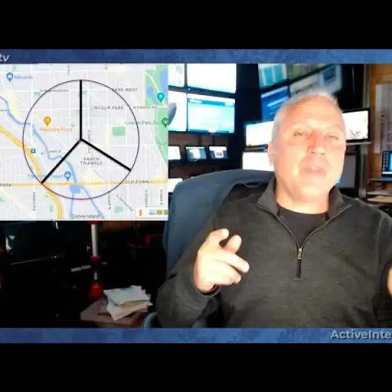
Here we see a map — we happened to just pick a map of suburbs of Chicago — and you see the streets on the map. This comes from Google Maps, and what we've drawn is a circle with three quadrants, suppose. Imagine that there's a cell tower right at the center of this circle where these three lines come together.
When you look at cell data from the cell company, it's going to tell you a number of things about that tower. It's going to tell you every device that's connected to it. So on each one of these streets there are people with cell phones, all of those devices will be connected to this tower. Even if you're not on the phone, it's going to ping that tower on a regular basis to know who is in the range.
And here's why — if you have your phone and you're driving down the street and a call comes in, the cell networks need to know where to send that call. So it pings your phone on a regular basis to know where you're at, so it's going to know you're in range of this tower. So if somebody calls you, it knows to route that call to this tower and then broadcast that call data out to you in that range.
So just because you're in range of that tower in this circle, it also will identify even more — it'll tell you what quadrants you're in, which of those three antenna sections is connecting to you. For example, if the connection section that's facing this way is the one that's connected to your phone, now you know that you're in this area.
So when a crime is committed or there's fraud or police are looking to find out where a person is, they can say, okay, this phone number 1234 is not only in this tower but it's in this quadrant, it's in this section. It's actually not a quadrant because it's a third — a quadrant would be a fourth — but it's in this sector of that cell coverage.
Well, that's still a big area. There's lots of streets there, there's a lot of location. How do you know where the person is? Well, you can take it a step further. You can also from the cell data determine the distance from the tower because when radio waves are broadcast from the tower to the phone and back to the tower, there's a certain amount of time. It's instantaneous — milliseconds — radio waves take to travel. So it can calculate based on the time that it's a certain distance from the tower. Let's say that distance is 400 meters, right, 400 meters from the tower.
So let's say here's a circle that's 400 meters from the tower. Well, you know that that cell connection is 400 meters away, but you also know it's within this sector. So you know it's somewhere along this line. It can't be over here because it's not in that sector, it can't be over here because it's not in that sector, it can't be in the middle here where Pequod's Pizza is, and it can't be outside here. It's got to be right along this line at that time.
But still, that's a lot of area to cover. But then you can also determine from the cell data what the speed of that vehicle is. If that vehicle or that device, presumably in a vehicle, is maintaining 400 meters and the distance is not changing, and it's going 70 miles an hour, well, where could it be? It can't be on Wrightwood Avenue because first of all, you probably can't go 70 miles an hour on Wrightwood Avenue. It can't be on this cross street because if it was here and remaining that distance, the distance would be getting shorter as you travel down the street.
But here's a section of the highway right here that stays right along that 400-meter distance, and you can go 70 miles an hour on that highway. So now the data will prove that during that period of time, the vehicle must have been traveling on this highway for that four or five minute period, however long that is.
So what can you do to find that vehicle? Now what you can do is you can look at traffic cameras, you can look at private security cameras to look at vehicles that were on that route at that time. So this is a very good way to prove the location of a person or of a device — where it was at a certain time.
And sometimes what law enforcement will do is if there's a crime committed — let's say Pequod's Pizza gets robbed at two o'clock in the afternoon — it'll do a tower dump. It'll dump all the data from that tower for that time period, and it will save it even if they're not going to use it right then. They'll dump the data, hold it in their records so they can compare it later to other records. Maybe a lot of the people in that tower dump are there all the time, maybe somebody works at Pequod's Pizza, maybe somebody works at another business in that area. They can eliminate those to know that those probably aren't the robber because they work there. They are eliminated.
But if there's a device that only was there during that course of that robbery, really doesn't come there before, wasn't there afterwards, well now you know that could be a potential suspect in that crime. Or if it's a private matter, you know a fraud case, divorce case, you can prove the same data.
So this is where cell phone records can help identify the location of a person at a certain date at a certain time.
On the other hand, if you have somebody who says, look, I didn't do this because at that time I was at Costco over here, I was shopping at Costco, there's no way I did that crime while shopping at Costco. Well, if they're shopping at Costco, first of all they're too far away to reach this tower, and if they weren't there at that time, it didn't make sense.
Also, what if they were down here on Goose Island and they said, look, I was on Goose Island when that robbery happened or when that fraud happened or when do you think that I was cheating on you with another woman? Well, that doesn't make sense because your phone shows up in this sector, not in this lower section sector of Ranch Triangle, Goose Island.
So there's a lot of records that can prove or disprove a person's story or their alibi, or show that they're at a certain place in time. If a subject, for example, is suspected to do money laundering or asset concealment, if you can show that they're going to a bank every single day at a certain time, which matches when there's ATM deposits, that's another way to use GPS data to prove the record.
So that is what you see visually when you see one of these cell towers. Each one of these sides is a sector in that triangle. Most of them are triangles, there's some that are four, and they will give you data because these antennas are connecting to your phone. They're recording the data off your phone — accelerometer, speed, altitude, sometimes barometer, sometimes it'll record other data being transmitted like text messages, phone calls, emails, and other records that that phone is exchanging. Or if you text a picture, sometimes it'll capture the photo.
So anytime you see one of these antennas, imagine that anything in this sector can be recorded and identified that it was on that direction and also the distance from that cell tower, and that can help solve a crime or prove data or facts in court.